 |
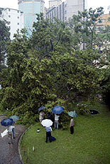
| Tempest trauma: A huge banyan tree in the Hong Kong Observatory grounds fell during inclement weather on September 13. |

|
September was cooler and wetter than usual. The mean temperature of 26.6 degrees Celsius was one degree lower than normal. The monthly rainfall of 420.2mm was 40% above normal.
Accumulated rainfall since January 1 amounted to 2,467.1mm, about 23% above the normal figure for the same period.
A southwesterly airstream brought fine and hot weather to Hong Kong for the first two days of the month. Under the influence of an upper air disturbance over the coast of southeastern China, the weather became showery on September 3 and 4.
A trough of low pressure over southern China moved south across coastal areas on September 7 and brought scattered showers and squally thunderstorms to Hong Kong. The weather remained cloudy with a few showers the next day.
The weather deteriorated with heavy rain on September 9 when a cold front crossed the south China coast. More than 100mm of rainfall was recorded in Sha Tin, Tai Po and the western part of Hong Kong Island and Kowloon. Under the influence of the northeast monsoon behind the cold front, it was cooler with some rain in the ensuing three days.
Storm situation
An area of low pressure over the northern part of the South China Sea developed into a tropical depression on September 12. Its outer rain band brought torrential rain to Hong Kong on September 13. Over 200mm of rain was recorded in most places around the city. There were over 30 reports of flooding and nine reports of landslide.
The weather improved on September 17 as a continental airstream prevailed over southern China.
After crossing the Philippines, Typhoon Xangsane entered the South China Sea on September 29 and moved westward towards Vietnam. Its outer cloud bands brought rain patches to Hong Kong on September 30.
Six tropical cyclones occurred in the western North Pacific and the South China Sea during the month.
Go To Top
|


