 |
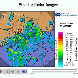
| Colour co-ordinated: Internet users can now track the movement and development of rain around Hong Kong by viewing the animated sequence of radar pictures on the Hong Kong Observatory's website. |

|
Internet users can now track the movement and development of rain around Hong Kong by viewing the animated sequence of radar pictures on the Hong Kong Observatory's website.
The animation features radar pictures over the last two hours at 12-minute intervals. Different colours represent rain intensity.
Hong Kong is at the centre of the picture with coverage extending 250km, encompassing most of Guangdong and the northern part of the South China Sea.
The observatory issues local weather forecasts and warnings that are in general valid for a larger region covering the whole of Hong Kong.
The animation allows the public to estimate whether their respective locations will be affected by rain, helping them better plan outdoor activities.
The observatory began offering the Course on Interpretation of Radar & Satellite Images last year, which was well received. Similar courses will be run to help people effectively use the website's radar and satellite information.
For information on the weather radar click here.
Go To Top
|