Flight check:
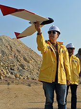
Civil Engineering & Development Department officers use the new Unmanned Aerial System.
Flight check:
Civil Engineering & Development Department officers use the new Unmanned Aerial System.
'Drone' aircraft bring survey boost
December 23, 2013
The Civil Engineering & Development Department today unveiled its new Unmanned Aerial System which has boosted its surveying work's efficiency and effectiveness.
Senior Land Surveyor Li Yuk-kwong briefed the media on the system today, which uses radio-controlled aircraft.
He said it helps surveyors capture all the site pictures they need in one day - work that can take up to three weeks using traditional methods.
The system is also safer and more flexible, he said, as it allows for dangerous landscapes to be surveyed, which may not be easily accessible.
The aerial photos can be processed with professional photogrammetric software to make survey products like 3D digital elevation models, oblique aerial photos, and videos.
The department acquired two of the unmanned aircraft last year, which have completed surveys of numerous sites, including Tseung Kwan O Fill Bank, Tuen Mun Fill Bank, and Anderson Road Quarry.


